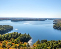
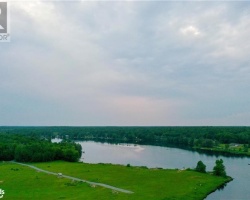
Gull Lake - (Gravenhurst)
Gull Lake is located in the geographic township of Muskoka within the Town of Gravenhurst. The northeastern portion of the lake is situated within the urban area of the Town of Gravenhurst. Hwy 11 passes over Gull Lake at the Narrows. Gull Lake flows into Lake Muskoka via the Hoc Roc River.
Average traveling time from the GTA to Gull Lake - (Gravenhurst) is 1 hour 36 mins
This Lake Median Lake Average Lake | |
Gull Lake is 134 hectares (331 Acres) in size The median size lake in our area is 71 hectares or 175 Acres (average size 398 hectares) | 134 71 398 |
|
Gull Lake has a maximum depth 8 meters (26 ft)
The median depth of lakes in our area is 13.5 m or 44 ft (average depth 18 m) | 8 13.5 18 |
| The median depth of Gull Lake is 4.40 m (14 ft) | 4.40 5.2 7 |
|
Gull Lake Perimeter 7.60 km (4.72 Miles)
The median perimiter of lakes in our area is 3.3 km or 2.05 miles (average Perimiter 3.61 km) | 7.60 3.3 4 |
| Gull Lake Island/s Perimeter 0.60 km (0.37 Miles) | |
|
Gull Lake Altitude 248 m (814 ft)
The median altitude of lakes in our area is 290 m or 951 ft (average Altitude is 289 m) | 248 290 289 |
|
Water Clarity of Gull Lake (median 3.2 m) 3.20 m (10ft)
The median Secchi Depth of lakes in our area is 3.2 m or 10 ft (average Secchi Depth is 3 m) | 3.20 3.2 3 |
| 5 % of Gull Lake shorline is wetland. The median percentage of shoreline which is wetland of lakes in our area is 9 % (average Percentage of shoreline which is wetland 10) % |
Percentage of Shoreline which is wetland 5 9 10 |
|
Gull Lake's phosphorus content in water is 6.90 ug/L
The median Phosphorus content in the water of lakes in our area is 8 ug/l (average Phosphorus content 9 ug/L | 6.90 8 9 |
| Gull Lake's watershed area feeding the Lake (excluding lake) 10.1 km2 (2496 acres) | |
| Lake Trout found in Gull Lake: No | |
| Drainage Basin of Gull Lake Lake Muskoka | |
| Gull Lake is in the Township of Muskoka | |
| Shoreline Development on Gull Lake is: High; urban, shoreline residential | |
| Public Access to Gull Lake Public; boat launches at Moody Drive and Hewitt St.,Shoreline access at Gull Lake municipal park on Bethune Drive in Gravenhurst Boat Launch | |
| Water Level Management Not regulated | |
| Major Fish Species in Gull Lake (I), (I) (I), (I 2017), rainbow trout (S) | |
| Other Fish Species in Gull Lake , , | |
| Notes: E: extirpated, I: introduced – intentional or accidental, O: occasional, R: remnant, S: currently stocked, ?: status uncertain, 2009: year of first record or introduction if known, blank: presumed native | |
| Much of the above data for Gull Lake is compliments of the Muskoka Water Web maintained by The District Municipality of Muskoka | |
Maps of Gull Lake
Topographical Map of Gull Lake in Gravenhurst
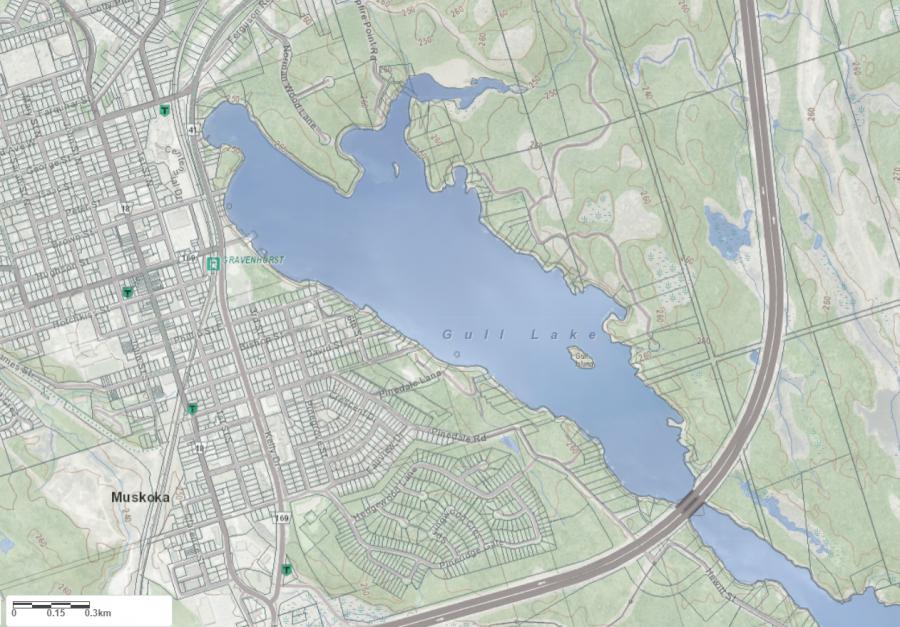
Legend
 Buildings surrounding Gull Lake
 Buildings surrounding Gull Lake
 Conservation Area surrounding Gull Lake
 Contours of land surrounding Gull Lake
 Index Contour
 Rapids
 Spot Height
 Water Falls
 Water Falls/Rapids
 Waterbody Elevation
 Watercourse
 Wetland surrounding Gull Lake
 Wooded Area surrounding Gull Lake
Zoning Map of Gull Lake in Gravenhurst
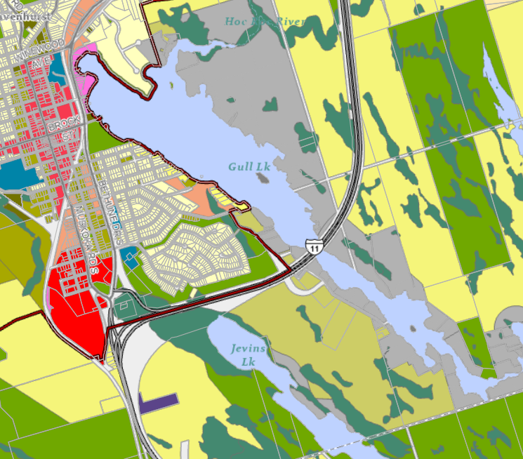
Legend of Gravenhurst Zoning Map - Gull Lake
Residential WaterfrontEnvironmentally Protected
Residential 1
Open Space
Rural
Residential Rural
Waterfront Landing
Residential Island
Commercial Recreational
Crown Land Map of Gull Lake in Gravenhurst
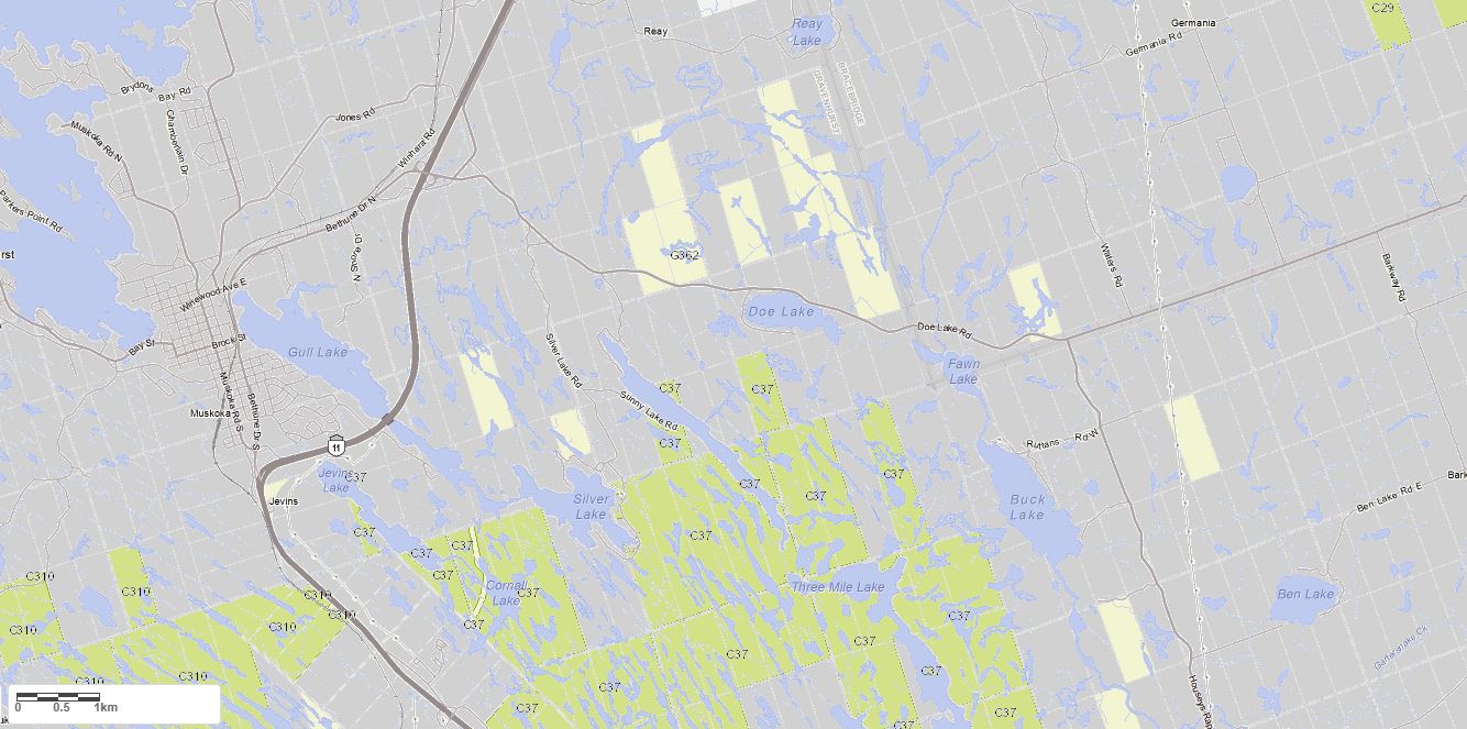
Legend for Crown Land Map
Private Land surrounding Gull Lake - (Gravenhurst)Provincial Park surrounding Gull Lake - (Gravenhurst)
Crown Land surrounding Gull Lake - (Gravenhurst) (General Use)
Conservation Reserve surrounding Gull Lake - (Gravenhurst)
Lake Contour Maps showing the depths of Gull Lake
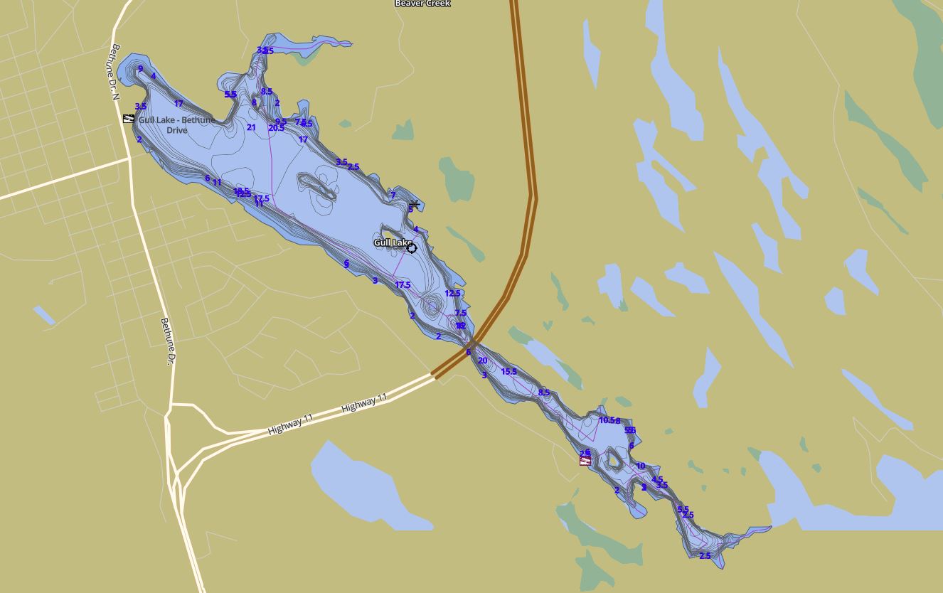
This map is courtesy of Gps Nautical Maps and you can purchase this map as an app from GpsNauticalCharts.com
All measurements of the countour map showing the depths of Gull Lake are in feet.
Islands on Gull Lake in Gravenhurst, Muskoka
| Official Name | Gull Island |
|---|---|
| Perimeter of Gull Island | 0.35 km (0.22 miles) |
| Area of Gull Island | 0.48 Hectares (1.19 Acres) |
| Properties on Gull Island | 1 |
| View on interactive Map | Locate Gull Island on Bing Maps |
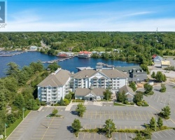
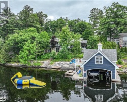
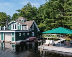
Cottages for Sale on Gull Lake
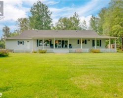
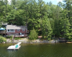
Cottages for Sale close to Gull Lake
Lake Videos
This video is courtesy of ecottagefilms.com This video is courtesy of ecottagefilms.com This video is courtesy of ecottagefilms.com This video is courtesy of ecottagefilms.com This video is courtesy of ecottagefilms.com This video is courtesy of ecottagefilms.com This video is courtesy of ecottagefilms.com Previously listed Cottages on Gull Lake
1110 Sandy Bay Road, Minden, K0M2K0 was previously listed 2024-02-26, mls# 40545544
54 Water Street, Minden, K0M2K0 was previously listed 2024-02-05, mls# 40537133
1110 SANDY BAY Road, Minden, K0M2K0 was previously listed 2023-10-31, mls# 40386862
600 GULL Lake, Gravenhurst, P1P1V5 was previously listed 2023-10-31, mls# 40441574
1482 FORSTERS Road, Minden, K0M2K0 was previously listed 2023-10-31, mls# 40448023
1030 SCHAEFER'S Road, Minden, K0M2K0 was previously listed 2023-10-31, mls# 40472845
1122 BOB BEENEY Trail, Minden, K0M2K0 was previously listed 2023-10-31, mls# 40474197
8056 HIGHWAY 35 N, Norland, K0M2L0 was previously listed 2023-10-31, mls# 40483263
1060 OXBOW Lane, Minden, K0M2K0 was previously listed 2023-10-31, mls# 40491898
1375 GULL Lake, Gravenhurst, P1P1V5 was previously listed 2023-10-31, mls# 40479372
1218 SANDY BAY Road, Minden, K0M2K0 was previously listed 2023-10-18, mls# 40450879
3526 MONCK Road, Norland, K0M2L0 was previously listed 2023-10-14, mls# 40428506
1220 U OF T SURVEY CAMP Drive, Minden, K0M2K0 was previously listed 2023-09-26, mls# 40456445
380 BETHUNE Drive N, Gravenhurst, P1P1B8 was previously listed 2023-09-01, mls# 40434115
1034 MARIPOSA Lane, Minden, K0M2K0 was previously listed 2023-08-23, mls# 40417926
1011 OSLER Lane, Minden, K0M2K0 was previously listed 2023-08-22, mls# 40460124
570 SIXTH Street, Gravenhurst, P1P1M2 was previously listed 2023-08-05, mls# 40457650
1063 MARIPOSA Lane, Minden, K0M2K0 was previously listed 2023-08-03, mls# 40429186
1031 LANDSIDE Trail, Minden, K0M2K0 was previously listed 2023-05-18, mls# 40406220
1025 & 1027 OSLER Lane, Minden Hills, K0M2K0 was previously listed 2023-04-26, mls# 40387320
1019 & 1025 & 1027 OSLER Lane, Minden Hills, K0M2K0 was previously listed 2023-04-26, mls# 40387336
1025 & 1027 OSLER Lane, Minden Hills, K0M2K0 was previously listed 2023-04-26, mls# 40387329
1019 & 1025 & 1027 OSLER Lane, Minden Hills, K0M2K0 was previously listed 2022-12-01, mls# 40331730
1220 U OF T SURVEY CAMP Drive, Minden, K0M2K0 was previously listed 2022-11-02, mls# 40314491
186 PINEDALE Lane, Gravenhurst, P1P1B4 was previously listed 2022-10-31, mls# 40290587
1110 SANDY BAY Road, Minden, K0M2K0 was previously listed 2022-10-14, mls# 40304775
2 VIVI Street, Coboconk, K0M1K0 was previously listed 2022-10-07, mls# 40248208
1763 RACKETY Trail, Minden, K0M2K0 was previously listed 2022-10-04, mls# 40293822
1019 & 1025 & 1027 OSLER Lane, Minden Hills, K0M2K0 was previously listed 2022-10-04, mls# 40296739
1025 & 1027 OSLER Lane, Minden Hills, K0M2K0 was previously listed 2022-10-04, mls# 40296752
1031 NELLIES Lane, Minden, K0M2K0 was previously listed 2022-09-07, mls# 40312377
1308 SCHAEFERS Road, Minden, K0M2K0 was previously listed 2022-09-01, mls# 40312595
. SUMAC Trail, Minden, K0M2K0 was previously listed 2022-09-01, mls# 40268169
1084 HUMPHREY Road, Minden, K0M2K0 was previously listed 2022-07-27, mls# 40293816
1073 SANDY BAY Road, Minden, K0M2K0 was previously listed 2022-07-27, mls# 40263671
1060 OXBOW Lane, Minden, K0M2K0 was previously listed 2022-07-27, mls# 40288690
1627 RACKETY Trail, Minden, K0M2K0 was previously listed 2022-07-27, mls# 40288307
1019 & 1025 & 1027 OSLER Lane, Minden Hills, K0M2K0 was previously listed 2022-07-27, mls# 40253771
1019 & 1025 & 1027 OSLER Lane, Minden, K0M2K0 was previously listed 2022-07-27, mls# 40255076
1693 RACKETY Trail, Minden Hills, K0M2K0 was previously listed 2022-07-01, mls# 40280018
1693 RACKETY Trail, Minden Hills, K0M2K0 was previously listed 2022-07-01, mls# 40268887
1099 Poster Lane, Minden Hills, K0M2L1 was previously listed 2022-03-10, mls# 40215673
1081 Griffith Court, Minden, K0M2K0 was previously listed 2022-01-12, mls# 40188362
3627 Monck Road, Norland, K0M2L0 was previously listed 2022-01-01, mls# 40171653
3866 Deep Bay Road, Minden, K0M2K0 was previously listed 2021-12-18, mls# 40192367
1081 Griffith Court, Minden, K0M2K0 was previously listed 2021-11-18, mls# 40170262
157 Shadow Lake 3 Road, Norland, K0M2L0 was previously listed 2021-11-10, mls# 40182995
1061 Leafy Branch Lane, Minden Hills, K0M2L1 was previously listed 2021-10-15, mls# 40164475
38 Albert Street, Coboconk, K0M2K0 was previously listed 2021-09-28, mls# 40159208
1012 Mariposa Lane, Minden, K0M2K0 was previously listed 2021-09-14, mls# 40138381
1117 Starlight Road, Minden, K0M2K0 was previously listed 2021-09-14, mls# 40139400
1187 Bob Beeney Trail, Minden, K0M2K0 was previously listed 2021-09-03, mls# 40154463
1212 Sandy Bay Road, Minden, K0M2K0 was previously listed 2021-08-25, mls# 40153555
3552 Monck Road, Norland, K0M2L0 was previously listed 2021-08-14, mls# 40147895
9593 Hwy 35 Highway, Minden Hills, K0M2K0 was previously listed 2021-08-14, mls# 40150391
9593a Hwy 35 Highway, Minden Hills, K0M2K0 was previously listed 2021-08-12, mls# 40150385
9593 Hwy 35 Highway, Minden/Haliburton, K0M2K0 was previously listed 2021-08-12, mls# 40150080
Lot 5 Sumac Trail, Minden, K0M2K0 was previously listed 2021-08-01, mls# 40100923
Lot 3 Sumac Trail, Minden, K0M2K0 was previously listed 2021-08-01, mls# 40100919
74 Shadow Lake Road 28, Coboconk, K0M1K0 was previously listed 2021-07-30, mls# 40136083
3526 Monck Road, Norland, K0M2L0 was previously listed 2021-07-29, mls# 40140585
1007 Loyalist Drive, Minden, K0M2K0 was previously listed 2021-07-26, mls# 40132038
326 Bethune Drive N, Gravenhurst, P1P1B8 was previously listed 2021-06-22, mls# 40124161
1127 Starlight Road, Minden, K0M2K0 was previously listed 2021-05-29, mls# 40111458
1027 Shetland Road, Haliburton, K0M2K0 was previously listed 2021-05-27, mls# 40116497
1124 Golden Rod Lane, Minden Hills, K0M1S0 was previously listed 2021-05-26, mls# 40087867
1100 Hewitt Street, Gravenhurst, P1P0A3 was previously listed 2021-05-20, mls# 40103270
570 Phillip Street E, Gravenhurst, P1P1M3 was previously listed 2021-05-05, mls# 40099852
1069 Hewitt Street, Gravenhurst, P1P1R1 was previously listed 2021-02-18, mls# 40064763
0 Schaefer Road, Minden Hills, K0M2K0 was previously listed 2021-01-25, mls# 280086
1029 Sprunt Lane, Gravenhurst, P1P1R1 was previously listed 2021-01-20, mls# 40052430
Lot 3 Sumac Trail, Minden, K0M2K0 was previously listed 2020-11-16, mls# 40014433
Lot 2 Sumac Trail, Minden, K0M2K0 was previously listed 2020-11-16, mls# 40014480
Lot 5 Sumac Trail, Minden, K0M2K0 was previously listed 2020-11-16, mls# 40014469
7690 Highway 35 . N, Norland, K0M2L0 was previously listed 2020-10-22, mls# 40008694
57 Invergordon Avenue, Minden, K0M2K0 was previously listed 2020-09-30, mls# 40016815
1029 Serenity Lane, Minden Hills, K0M2K0 was previously listed 2020-06-16, mls# 247429
330 Bethune Drive E, Gravenhurst, P1P1B8 was previously listed 2020-02-26, mls# 233764
326 Bethune Drive N, Gravenhurst, P1P1B8 was previously listed 2020-02-26, mls# 231101
1944 Deep Bay Road #a, Minden, K0M 2K0 was previously listed 2019-12-27, mls# 183450
1029 Forsters Road, Minden Hills, K0M 2K0 was previously listed 2019-12-27, mls# 218998
326 Bethune Drive N, Gravenhurst, P1P 1B8 was previously listed 2019-10-31, mls# 212035
1176 Sandy Bay Road, Minden, K0M 2K0 was previously listed 2019-10-22, mls# 207812
1029 Serenity Lane, Minden Hills, K0M 2K0 was previously listed 2019-10-16, mls# 184764
1206 North Shore Drive, Gravenhurst, P1P 1B4 was previously listed 2019-10-08, mls# 221973
1206 North Shore Drive, Gravenhurst, P1P 1B4 was previously listed 2019-09-16, mls# 215772
1300 Gull Lake, Gravenhurst, P1P 1R1 was previously listed 2019-09-06, mls# 216151
1206 North Shore Drive, Gravenhurst, P1P 1B4 was previously listed 2019-08-14, mls# 207726
260 Bethune Drive N, Gravenhurst, P1P 1H4 was previously listed 2019-08-06, mls# 208051
1901 Rackety Trail Road, Minden, K0M 2K0 was previously listed 2019-08-06, mls# 206780
1047 Hewitt Street, Gravenhurst, P1P 0A3 was previously listed 2019-08-06, mls# 202501
Lake Videos
Previously listed Cottages on Gull Lake
1110 Sandy Bay Road, Minden, K0M2K0 was previously listed 2024-02-26, mls# 40545544
54 Water Street, Minden, K0M2K0 was previously listed 2024-02-05, mls# 40537133
1110 SANDY BAY Road, Minden, K0M2K0 was previously listed 2023-10-31, mls# 40386862
600 GULL Lake, Gravenhurst, P1P1V5 was previously listed 2023-10-31, mls# 40441574
1482 FORSTERS Road, Minden, K0M2K0 was previously listed 2023-10-31, mls# 40448023
1030 SCHAEFER'S Road, Minden, K0M2K0 was previously listed 2023-10-31, mls# 40472845
1122 BOB BEENEY Trail, Minden, K0M2K0 was previously listed 2023-10-31, mls# 40474197
8056 HIGHWAY 35 N, Norland, K0M2L0 was previously listed 2023-10-31, mls# 40483263
1060 OXBOW Lane, Minden, K0M2K0 was previously listed 2023-10-31, mls# 40491898
1375 GULL Lake, Gravenhurst, P1P1V5 was previously listed 2023-10-31, mls# 40479372
1218 SANDY BAY Road, Minden, K0M2K0 was previously listed 2023-10-18, mls# 40450879
3526 MONCK Road, Norland, K0M2L0 was previously listed 2023-10-14, mls# 40428506
1220 U OF T SURVEY CAMP Drive, Minden, K0M2K0 was previously listed 2023-09-26, mls# 40456445
380 BETHUNE Drive N, Gravenhurst, P1P1B8 was previously listed 2023-09-01, mls# 40434115
1034 MARIPOSA Lane, Minden, K0M2K0 was previously listed 2023-08-23, mls# 40417926
1011 OSLER Lane, Minden, K0M2K0 was previously listed 2023-08-22, mls# 40460124
570 SIXTH Street, Gravenhurst, P1P1M2 was previously listed 2023-08-05, mls# 40457650
1063 MARIPOSA Lane, Minden, K0M2K0 was previously listed 2023-08-03, mls# 40429186
1031 LANDSIDE Trail, Minden, K0M2K0 was previously listed 2023-05-18, mls# 40406220
1025 & 1027 OSLER Lane, Minden Hills, K0M2K0 was previously listed 2023-04-26, mls# 40387320
1019 & 1025 & 1027 OSLER Lane, Minden Hills, K0M2K0 was previously listed 2023-04-26, mls# 40387336
1025 & 1027 OSLER Lane, Minden Hills, K0M2K0 was previously listed 2023-04-26, mls# 40387329
1019 & 1025 & 1027 OSLER Lane, Minden Hills, K0M2K0 was previously listed 2022-12-01, mls# 40331730
1220 U OF T SURVEY CAMP Drive, Minden, K0M2K0 was previously listed 2022-11-02, mls# 40314491
186 PINEDALE Lane, Gravenhurst, P1P1B4 was previously listed 2022-10-31, mls# 40290587
1110 SANDY BAY Road, Minden, K0M2K0 was previously listed 2022-10-14, mls# 40304775
2 VIVI Street, Coboconk, K0M1K0 was previously listed 2022-10-07, mls# 40248208
1763 RACKETY Trail, Minden, K0M2K0 was previously listed 2022-10-04, mls# 40293822
1019 & 1025 & 1027 OSLER Lane, Minden Hills, K0M2K0 was previously listed 2022-10-04, mls# 40296739
1025 & 1027 OSLER Lane, Minden Hills, K0M2K0 was previously listed 2022-10-04, mls# 40296752
1031 NELLIES Lane, Minden, K0M2K0 was previously listed 2022-09-07, mls# 40312377
1308 SCHAEFERS Road, Minden, K0M2K0 was previously listed 2022-09-01, mls# 40312595
. SUMAC Trail, Minden, K0M2K0 was previously listed 2022-09-01, mls# 40268169
1084 HUMPHREY Road, Minden, K0M2K0 was previously listed 2022-07-27, mls# 40293816
1073 SANDY BAY Road, Minden, K0M2K0 was previously listed 2022-07-27, mls# 40263671
1060 OXBOW Lane, Minden, K0M2K0 was previously listed 2022-07-27, mls# 40288690
1627 RACKETY Trail, Minden, K0M2K0 was previously listed 2022-07-27, mls# 40288307
1019 & 1025 & 1027 OSLER Lane, Minden Hills, K0M2K0 was previously listed 2022-07-27, mls# 40253771
1019 & 1025 & 1027 OSLER Lane, Minden, K0M2K0 was previously listed 2022-07-27, mls# 40255076
1693 RACKETY Trail, Minden Hills, K0M2K0 was previously listed 2022-07-01, mls# 40280018
1693 RACKETY Trail, Minden Hills, K0M2K0 was previously listed 2022-07-01, mls# 40268887
1099 Poster Lane, Minden Hills, K0M2L1 was previously listed 2022-03-10, mls# 40215673
1081 Griffith Court, Minden, K0M2K0 was previously listed 2022-01-12, mls# 40188362
3627 Monck Road, Norland, K0M2L0 was previously listed 2022-01-01, mls# 40171653
3866 Deep Bay Road, Minden, K0M2K0 was previously listed 2021-12-18, mls# 40192367
1081 Griffith Court, Minden, K0M2K0 was previously listed 2021-11-18, mls# 40170262
157 Shadow Lake 3 Road, Norland, K0M2L0 was previously listed 2021-11-10, mls# 40182995
1061 Leafy Branch Lane, Minden Hills, K0M2L1 was previously listed 2021-10-15, mls# 40164475
38 Albert Street, Coboconk, K0M2K0 was previously listed 2021-09-28, mls# 40159208
1012 Mariposa Lane, Minden, K0M2K0 was previously listed 2021-09-14, mls# 40138381
1117 Starlight Road, Minden, K0M2K0 was previously listed 2021-09-14, mls# 40139400
1187 Bob Beeney Trail, Minden, K0M2K0 was previously listed 2021-09-03, mls# 40154463
1212 Sandy Bay Road, Minden, K0M2K0 was previously listed 2021-08-25, mls# 40153555
3552 Monck Road, Norland, K0M2L0 was previously listed 2021-08-14, mls# 40147895
9593 Hwy 35 Highway, Minden Hills, K0M2K0 was previously listed 2021-08-14, mls# 40150391
9593a Hwy 35 Highway, Minden Hills, K0M2K0 was previously listed 2021-08-12, mls# 40150385
9593 Hwy 35 Highway, Minden/Haliburton, K0M2K0 was previously listed 2021-08-12, mls# 40150080
Lot 5 Sumac Trail, Minden, K0M2K0 was previously listed 2021-08-01, mls# 40100923
Lot 3 Sumac Trail, Minden, K0M2K0 was previously listed 2021-08-01, mls# 40100919
74 Shadow Lake Road 28, Coboconk, K0M1K0 was previously listed 2021-07-30, mls# 40136083
3526 Monck Road, Norland, K0M2L0 was previously listed 2021-07-29, mls# 40140585
1007 Loyalist Drive, Minden, K0M2K0 was previously listed 2021-07-26, mls# 40132038
326 Bethune Drive N, Gravenhurst, P1P1B8 was previously listed 2021-06-22, mls# 40124161
1127 Starlight Road, Minden, K0M2K0 was previously listed 2021-05-29, mls# 40111458
1027 Shetland Road, Haliburton, K0M2K0 was previously listed 2021-05-27, mls# 40116497
1124 Golden Rod Lane, Minden Hills, K0M1S0 was previously listed 2021-05-26, mls# 40087867
1100 Hewitt Street, Gravenhurst, P1P0A3 was previously listed 2021-05-20, mls# 40103270
570 Phillip Street E, Gravenhurst, P1P1M3 was previously listed 2021-05-05, mls# 40099852
1069 Hewitt Street, Gravenhurst, P1P1R1 was previously listed 2021-02-18, mls# 40064763
0 Schaefer Road, Minden Hills, K0M2K0 was previously listed 2021-01-25, mls# 280086
1029 Sprunt Lane, Gravenhurst, P1P1R1 was previously listed 2021-01-20, mls# 40052430
Lot 3 Sumac Trail, Minden, K0M2K0 was previously listed 2020-11-16, mls# 40014433
Lot 2 Sumac Trail, Minden, K0M2K0 was previously listed 2020-11-16, mls# 40014480
Lot 5 Sumac Trail, Minden, K0M2K0 was previously listed 2020-11-16, mls# 40014469
7690 Highway 35 . N, Norland, K0M2L0 was previously listed 2020-10-22, mls# 40008694
57 Invergordon Avenue, Minden, K0M2K0 was previously listed 2020-09-30, mls# 40016815
1029 Serenity Lane, Minden Hills, K0M2K0 was previously listed 2020-06-16, mls# 247429
330 Bethune Drive E, Gravenhurst, P1P1B8 was previously listed 2020-02-26, mls# 233764
326 Bethune Drive N, Gravenhurst, P1P1B8 was previously listed 2020-02-26, mls# 231101
1944 Deep Bay Road #a, Minden, K0M 2K0 was previously listed 2019-12-27, mls# 183450
1029 Forsters Road, Minden Hills, K0M 2K0 was previously listed 2019-12-27, mls# 218998
326 Bethune Drive N, Gravenhurst, P1P 1B8 was previously listed 2019-10-31, mls# 212035
1176 Sandy Bay Road, Minden, K0M 2K0 was previously listed 2019-10-22, mls# 207812
1029 Serenity Lane, Minden Hills, K0M 2K0 was previously listed 2019-10-16, mls# 184764
1206 North Shore Drive, Gravenhurst, P1P 1B4 was previously listed 2019-10-08, mls# 221973
1206 North Shore Drive, Gravenhurst, P1P 1B4 was previously listed 2019-09-16, mls# 215772
1300 Gull Lake, Gravenhurst, P1P 1R1 was previously listed 2019-09-06, mls# 216151
1206 North Shore Drive, Gravenhurst, P1P 1B4 was previously listed 2019-08-14, mls# 207726
260 Bethune Drive N, Gravenhurst, P1P 1H4 was previously listed 2019-08-06, mls# 208051
1901 Rackety Trail Road, Minden, K0M 2K0 was previously listed 2019-08-06, mls# 206780
1047 Hewitt Street, Gravenhurst, P1P 0A3 was previously listed 2019-08-06, mls# 202501