Blue Lake - (Seguin)
There another 3 Blue Lake's : Blue Lake in Ridout of Lake of Bays Blue Lake in Hagerman of Whitestone Blue Lake in Proudfoot of Kearney
Average traveling time from the GTA to Blue Lake - (Seguin) is 2 hours 14 min
This Lake Median Lake Average Lake | |
Blue Lake is 25 hectares (62 Acres) in size The median size lake in our area is 71 hectares or 175 Acres (average size 398 hectares) | 25 71 398 |
|
Blue Lake has a maximum depth 18 meters (59 ft)
The median depth of lakes in our area is 13.5 m or 44 ft (average depth 18 m) | 18 13.5 18 |
| The median depth of Blue Lake is 8.00 m (26 ft) | 8.00 5.2 7 |
|
Blue Lake Perimeter 4.40 km (2.73 Miles)
The median perimiter of lakes in our area is 3.3 km or 2.05 miles (average Perimiter 3.61 km) | 4.40 3.3 4 |
| Blue Lake Island/s Perimeter 0.10 km (0.06 Miles) | |
|
Blue Lake Altitude 207 m (679 ft)
The median altitude of lakes in our area is 290 m or 951 ft (average Altitude is 289 m) | 207 290 289 |
| Blue Lake's watershed area feeding the Lake (excluding lake) 0.8 km2 (198 acres) | |
| Drainage Basin of Blue Lake Boyne River | |
| Blue Lake's percentage of shoreline which is Crown Land 10 % | |
| Blue Lake is in the Township of Foley | |
| Shoreline Development on Blue Lake is: moderate; shoreline residential | |
| Public Access to Blue Lake private | |
| Water Level Management not regulated | |
| Major Fish Species in Blue Lake splake (S), , | |
| Other Fish Species in Blue Lake , creek chub, northern redbelly dace | |
| Notes: E: extirpated, I: introduced – intentional or accidental, O: occasional, R: remnant, S: currently stocked, ?: status uncertain, 2009: year of first record or introduction if known, blank: presumed native | |
| Much of the above data for Blue Lake is compliments of the Muskoka Water Web maintained by The District Municipality of Muskoka | |
Maps of Blue Lake
Topographical Map of Blue Lake in Seguin
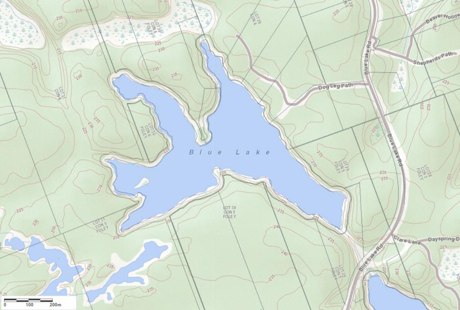
Legend
 Buildings surrounding Blue Lake
 Buildings surrounding Blue Lake
 Conservation Area surrounding Blue Lake
 Contours of land surrounding Blue Lake
 Index Contour
 Rapids
 Spot Height
 Water Falls
 Water Falls/Rapids
 Waterbody Elevation
 Watercourse
 Wetland surrounding Blue Lake
 Wooded Area surrounding Blue Lake
Lake Contour Maps showing the depths of Blue Lake
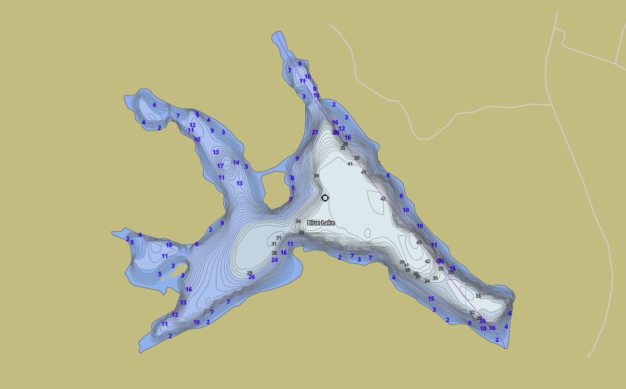
This map is courtesy of Gps Nautical Maps and you can purchase this map as an app from GpsNauticalCharts.com
All measurements of the countour map showing the depths of Blue Lake are in feet.
Cottages for Sale on Blue Lake - (Seguin)
Sorry no cottages for sale at the moment on Blue Lake (Seguin)
Cottages for Sale close to Blue Lake
Previously listed Cottages on Blue Lake
1055 BLUE LAKE Road, Huntsville, P1H2J6 was previously listed 2023-10-31, mls# 40470727


Previously listed Cottages on Blue Lake
1055 BLUE LAKE Road, Huntsville, P1H2J6 was previously listed 2023-10-31, mls# 40470727